 Recently unearthed evidence, aided by computer technology, points to a town in Galilee as the possible Cana of miracles.
Three sites – two in Israel, one in Lebanon – are presumed to be the biblical Cana, the town where Christians believe Jesus performed the miracle of turning water into wine. Because of this, each of the sites has has attracted pilgrims throughout the centuries.
The “true” location has been searched in Qana, 10 kms southeast of Tyre and Kafr Kenna next to Nazareth, however, no remains of the Roman period were foundat either site.
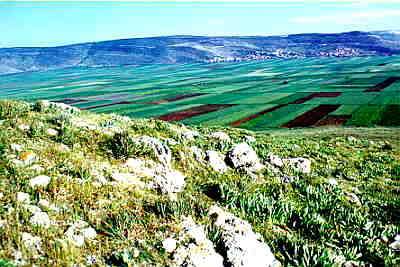
It is the third of these sites, Khirbet (ruin of) Cana – a site in the Galilee, 8 miles northwest of Nazareth and 12 miles west of the Sea of Galilee, which seems the most likely “candidate” in the quest for the true location of Cana.
Recent archaeological evidence points to it as the location of the biblical town mentioned in the Gospel of John (John 2: 1-11) where Jesus, attending a marriage feast with his mother and his disciples turned water into wine. The preliminary findings support this theory: thus, for instance, some 25% of the plentiful pottery uncovered here stems from the late Hellenistic and early Roman, and 50% from the Byzantine Period.
 Professor Douglas R EdwardsThe site is being excavated by a team of archaeologists under the direction of Professor Douglas R. Edwards of the University of Puget Sound, Tacoma, Washington. According to Prof. Edwards, this spot, on the north side of an important trade route, the Bet Netofa Valley, was a destination for pilgrims already as early as the 5th century CE, and the amount of imported pottery indicates the possibility that these pilgrims came in large numbers.
“Cana and its environs represent an intriguing location,” states Edwards. “It had a long time religious association as the site where Jesus turned water into wine. It became one of the villages settled by one of the Jewish priestly families after the destruction of the Jerusalem Temple. And it lies along an east-west thoroughfare, at least through the Byzantine Period. The historical periods for Galilee generally receive little attention, in large measure because of the plethora of literary evidence. But texts provide only a small window into the very complex societies of which they were a part.”
 Some 70 enthusiastic archaeologists, college students and graduates, and individual volunteers spent 5 weeks in the months of July and August in 1998,1999 and 2000 (at least two more seasons are being planned), digging, photographing, drawing, digitizing, discussing and analyzing finds – vestiges of life from ancient days – fitting together clues as to how our ancestors lived, worked, played, fought and died.
There were many specialists among the participants, including, archaeologists, geologists, anthropologists, architects, photographers, chemists, paleozoologists, paleobotanists, ceramics specialists, scientific illustrators, and specialists in GIS, GPS and carbon dating. They spent from 5 a.m. to 1 o’clock noon (with breaks for rest and breakfast) on that hill in Lower Galilee engaged in their serious search.
Accommodations were luxurious by archaeological standards. The participants were lodged at the Hasolelim Country Inn, in air-conditioned rooms at a kibbutz just outside of Nazareth. There were opportunities to swim in the kibbutz private swimming pool, and play tennis and basketball on the premises.
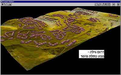
 Geographical points were mapped out using information gathered from the Trimble Positioning System (GPS)- Trimble Pro-XR and Trimble 4800; in this way, longitude and latitude of a location were measured within 1cm accuracy. These coordinates were then stored in the computer which was later plugged into a larger system for data retrieval. Maps were then produced via GIS, and as new structures are uncovered, their location is programmed and added to the new maps – thus up-to-date maps of the dig site are available at all times.
Ancient walls, pottery, glass, many building remains and other artifacts littering the site today are silent witnesses to a town which at its peak, was home to some 1000 people.
Caves, tombs and cisterns (some 60), ancient walls and Christian artifacts unearthed during three excavation seasons offer concrete hints for the archaeologists’ theories. The earliest evidence of human occupation were stone tools from the Neolithic Period and the latest evidence dates from the Turkish Period, testifying to the town’s long life and continued habitation from as early as the 5th millennium BCE to as late as the 19th-20th century CE. The largest number of ceramic remains comes from the Early Roman and Byzantine Periods, while the earliest architectural feature is a rectangular building from the Early Roman Period. The building has fine wall plaster with a well-constructed plaster floor and a pilaster which suggests a second story.
 On top of an acropolis of some 12 and a half acres are some large building stones, possibly from an old city wall, as well as the remains of a large complex (ca. 70×60 meters) which may have been a church or a monastery. It is believed that this wall, probably from the sixth or seventh century, was hastily built during the last vestiges of the town on the acropolis. This complex has a “mystery cave”, possibly associated with a synagogue, and a dovecote, believed to date from either the Hellenistic or Byzantine period and suggesting possible commercial as well as agricultural activity.
There is a Byzantine storage area with steps, and an earlier complex, with what may be a Roman road,
Earlier complex under church, with possible Roman road. Earlier complex under church, with possible Roman road.
And a huge “mystery” rock adds to the questions to be answered.
 For reasons unknown, the inhabitants of this area moved to a lower slope during the Middle Ages and the population dwindled to an estimated 100-150 people. According to Professor Edwards, evidence suggests that this lower site may have contained the “Church of the Master of the Feast” mentioned by ancient writers as the pilgrim site of the “water-in-wine” miracle.
The pilgrim cave has graffiti (including Greek) and crosses drawn on several layers of wall plaster. A portion of the cobbled floor on which pilgrims apparently walked has been partially excavated and dated to the sixth century. A special display greeted the pilgrims as they entered the now blocked up entrance. It included a re-used sarcophagus lid turned on its side with at least one cross incised on the side facing the pilgrims. Stone containers, two of which remain in place, were plastered to the wall and the re-used sarcophagus. These containers may well have held the water vessels that pilgrims believed were associated with the water to wine miracle. Marble fragments with gold leaf that were found in the fill indicate that the site was elaborate if not spectacular. Steps lead to lower caves that have as yet been unexcavated.
 Among the artifacts found on the site is an obsidian arrow head, probably imported from Turkey, and a cylinder seal probably from the Assyrian or Persian period, which shows two bearded robed men with staffs facing each other, with a tree of life between them, a winged sun, a griffin and an ibex. Unearthed, too, were two silver Tyrian coins dating to the 4th century BCE, coins from the second century BCE indicating important links to the Greek speaking Seleucid empire, and Maccabean coins and pottery.
Field architect Aaro Soederlund from Finland digitized the finds, first in 2D, later in 3D format. “The Pilgrim Cave is perhaps the most extraordinary place in Cana,” he says. “It consists of at least five spatial units. As we measured it, manually, we used the base line method. Against that we were then able to erect the sectional horizontal sub-lines in a 90 degrees angle to it. Photos were taken systematically both by digital and traditional cameras and used as a reference when modeling the details.” Sony and Nikon digital cameras, a 35mm camera and Sony Digital Video camera were used to record images.
A scanner was used for digitizing the field drawings for guidelines under the CAD-views The scanner was used also for taking the height data from detailed topographical maps to model the correct shape to the landscape, on top of which the archaeological details were then added.
As the principal modelling and drawing tool ArchiCAD 6.5 and ArchiTerra turned out to be fast and almost inexhaustible. In addition to documentary plans and surface models, animations, QTVR (Quicktime Virtual Reality) models and still images were produced with ArchiCAD 6.5 add-ons.
 “The drawings were scanned into the computer where they were used under the ArchiCAD screens showing the respective plans and sections. When the ‘sculpted’ model was in balance with the drawings on all of the screens, it was ready to be used for producing field-stills, animations and QTVR’s.”
As for the cisterns, Soederlund continues, the modeled group of cisterns is the richest known to date: a small bell-shaped (believed to be a) silo with skylight, another big bell-shaped cistern with a big skylight, an angled plastered staircase leading down to a plastered mikve (ritual bath) and a big rectangular (sewage) cistern
From the beginning of the dig in 1998 GIS technology has been integrated in the work. ArcView GIS combines orthophotos, reports, databases and surveys for analysis by the excavation team as well as by future excavators. The team also develops a virtual world in which students, the general public and scholars can view the reconstructed site. This virtual world is presented in two forms: one uses ArcExplorer, the other draws on Dreamworld technology. The latter allows persons to move around a virtual world that presents three-dimensional views of the site. Real archaeology through GIS technology has moved into the virtual world and serves as an educational, scientific and research tool.
Cana of the Galilee: Archaeology Field School

